Grid Gone Wild
A Walk Through Variations in the Public Land Survey System (PLSS)
Different parts of the US have historically used different methods for designating land boundaries.
These days, the Bureau of Land Management (BLM) looks after this. Much of the country falls under the Public Land Survey System (PLSS), essentially dividing land into squares, then smaller squares, and then even smaller squares.
That’s the basic idea, at least.
But it starts to get complicated very quickly.
* Note that measurements are approximate and for discussion purposes only.
The Perfect Township
A township like this one in Kansas conforms to the ideal. The township (shown in blue) is 6 miles by 6 miles square, and is broken down into 36 sections (in red) of one square mile each.
The sections are numbered sequentially, 1 through 36, starting in the northeast corner and winding their way down.

Aliquot Parts: Getting Smaller With Math
A section is still a pretty big piece of land - one square mile, 640 acres. We need a way to describe smaller areas. So we divide those sections into quarters, and then quarters of quarters.
Aliquots are a way to describe these - for example, the piece of land shown here would be the NW quarter of the NW quarter of Section 1.

The aliquot parts are created mathematically, by dividing the larger polygon. But look closer at these ones - they’re not very square. Why?
There are many reasons why sections may not be square, or even rectangular at all. Often it has to do with history, honoring previous surveys and survey methods. Some of it has to do with convergence of longitude (getting closer together the further north you go). Some of it has to do with inaccurate surveying.
The point is that variations and exceptions exist all over the place, and we have to deal with them.
Government Lots
Government lots are a way of handling variations. They’re not “lots” in the real estate sense of a parcel of land to build your house on - they’re exceptions to the standard survey methodology.
We’ll show lots in pale yellow.
One of the most common scenarios is encountered at the north and east sides of the township, where the final sections aren’t the right size or shape for the aliquot method to produce good results.

How much does this matter? A lot. (Pun intended.)
In the next example, section 1 is taller than it is wide. To handle the difference, the top row of quarter-quarters have been replaced by lots, numbered 1 through 4.
The difference in the position of the southern edge is over 1200 feet. The difference in acreage is substantial - an aliquot quarter-quarter is expected to be 40 acres, but this lot is nearly double that at 79.72 acres.

If you are mapping land smaller than a section using math (as is often done), without actual lot data, your positions and calculations can be way, WAY off.
Tracts: A Catch-All of Exceptions
Let’s complicate things further.
There are many, many irregularly shaped pieces of land designated, going back hundreds of years, that cover everything from reserves and mining claims to Spanish-rule ranchos.
Newer surveys must honor older surveys, so the PLSS pieces together these pre-existing tracts with conventional surveys and government lots to produce a patchwork quilt of land, as you can see in this next township.
Lots are shown in yellow and tracts are pale blue.

Newer surveys must honor older surveys.
Counting 1, 2, 3… 8?
You might have noticed earlier that the government lots appeared to be numbered sequentially, much like sections. So they’re predictable, right?
No.
If they are re-surveyed, and change more than a certain amount, they get a new number. The original number isn’t re-used.
The lot numbers in this section in South Dakota are 1, 2, 3, 4, 6, 8, 9, 11, 15, 16, 17, 19.
Between the lots (yellow) and tracts (blue) here with one lonely conventional quarter-quarter, the aliquot method wouldn’t even come close to describing the contents of this section.
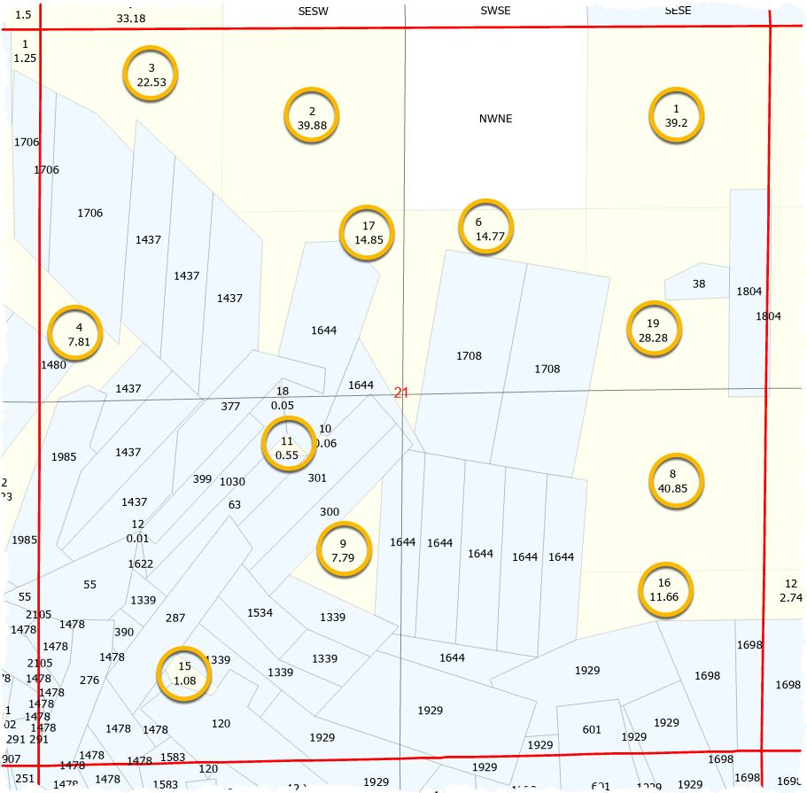
The aliquot method wouldn’t even come close.
A River Runs Through It
These examples (so far!) have at least had straight-ish lines for edges.
What happens when you come up against a body of water? All the rules change.
In some parts of the country, such as Louisiana, French settlement “long lots” line the waterfront.
In this Louisiana township, the Mississippi River results in a mix of sections (white), lots (yellow), and tracts (blue). Where you would expect to find 36 sections, we see over 70. The adjacent township to the east appears to have more than 80.

French settlement “long lots” line the waterfront.
Even where long lots aren’t in use, rivers wreak havoc like the lots in this section (also in Louisiana).

Rivers wreak havoc.
And rivers move over time, which is an entirely different conversation, with mitigation methods varying at the local level.
Parcels: A Different Creature Entirely
So where do parcels fall in this mish-mash?
Consider this tract in California, originally a Spanish-era rancho. The red boundary shows the limits of the tract survey, considered part of the PLSS.
Inside, it’s chock full of tiny parcels in green. The parcels honor the tract survey - but they’re not part of the PLSS, and are generally the responsibility of local government.

This also means that sourcing parcel data involves literally thousands of individual counties across the country - unlike the BLM’s centralization of the PLSS.
WhiteStar
Working all of these elements into a cohesive, convenient, and usable single source is what we do.
Read more here: