The Evolution of Mapping Data
The Internet has been around a long time. Most people under 30 do not remember a time before the Internet. Tim Berners-Lee invented the World Wide Web in 1990. Not long after, GIS visionaries began to stream map data using this new technology, freeing users from the need to store and manage vast amounts of local map data, as well as to publish the most up-to-date data in their maps avoiding a cumbersome update process.
In the mid-1990s, MapServer was developed at the University of Minnesota in cooperation with NASA and the Minnesota Department of Natural Resources. MapServer is an open source web mapping project with the ability to publish map content to the web.
In 1999, the Open Geospatial Consortium (OGC) developed the Web Map Service (WMS) protocol standard. The WMS protocol allows a GIS server and database to publish georeferenced map tiles.
In 2001, the OGC developed the Web Feature Service (WFS) protocol. This standard created a new methodology for geographic data handling on the web. Geographic data could now be created, edited and modified directly through the web. Performance in these early web mapping days was primarily limited by bandwidth and server capacity. Widespread adoption was limited because of the requirement for a highly technical understanding of geodatabases and web protocol. Most vendors now support the OGC protocols, including Esri which supported it very early.
In June 2000 Esri released Arc Internet Map Server (ArcIMS). This was Esri’s first GIS effort to serve maps across the Internet. The data behind the map was stored either inside ArcSDE or Shape files.
Google Earth was launched June 11, 2001. Though not a true GIS system, this release revolutionized web mapping and opened web mapping to a worldwide audience. Google Earth is a WMS client featuring data import capabilities, for example via the Keyhole Markup Language (KML) that allows users to add data to the preloaded base maps. In subsequent releases, users could add their own Shapefiles for display alongside other datasets. Google Earth significantly lowered the barriers of entry to the web mapping arena.
ArcGIS Server was released in May 2004, and is the core server technology used across the entire Esri platform, including desktop and mobile clients.
The next 15 years saw major advancements in open source projects, Google, and Esri, not to mention a variety of other vendors and projects. I’ve been fortunate enough to participate in this rapid transformation of technology every step of the way. Here at WhiteStar we have adopted the most commonly used web service protocols - OGC WFS/WMS and Esri map and feature services.
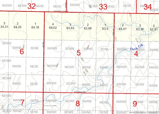
ArcGIS Web Map service consisting of WhiteStar Grid with Lots, Tracts and Quarter-quarters and WhiteStar Culture within ArcGIS Pro.
Web services are great because they bring you instant access to the most up-to-date data right within your GIS application. In the image above we overlay WhiteStar Grid with Lots, Tracts, and Quarter-Quarters in an area in Kansas, in conjunction with WhiteStar Culture. The surface contours and streams are visible along with the PLSS sections, lots, tracts and quarter-quarter data. Traditional data management is eliminated and the workflow is simplified and more efficient.